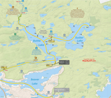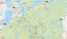
2025 Kawartha Highlands Paddling Map
With the Maps By Jeff Kawartha Highlands Camp & Paddle Map, get ready to see more of the Kawartha Highlands Provincial Park than ever before - now including Petroglyphs Provincial Park, and surrounding Crown lands. Maps By Jeff (Unlostify) maps are tear proof, waterproof, and even float.
The Kawartha Highlands Map by Unlostify features two distinct maps in one: a re-useable, erasable, whiteboard planning map - complete with 13 water access points in the area and info on canoe rentals, supplies, and free parking. All campsites, reservable park sites, and crown land free sites, are clearly marked and numbered, and all portages are graded for difficulty, as well as length, steepness, and time. Draw out multiple trip itineraries until you've nailed down the one that suits you best.
Once on your trip, flip the map over, and use the waterproof, tear-proof trip side of the map to plot your course along the route you've chosen. Glow-in-the-dusk inks ensure that low light or poor conditions don't complicate your map reading.
With the Unlostify Kawartha Highlands Camping Map, you’ll know all the shortcuts and secret routes in Ontario’s newest park like you’ve been travelling these waters forever - not a single billion-year-old metasedimentary stone is left unturned.
Portage Elevation Profiles
“At least this portage is short.” Famous last words.
It turns out that the hardest portages aren’t always the longest ones – they’re the ones with a mountain or two in the middle.
Now, thanks to the portage elevation profiles, you’ll know where the hills are before you go.
Distances & Travel Times
Each stretch of canoe route is labelled with both the distance, and an estimated travel time.
Since we all travel at different speeds over different terrains (e.g. we’re faster on big lakes and slower on portages), they'll help you avoid planning a route that has you arriving at your campsite at 9pm.
Not only do they consider paddling vs. portaging speeds, but they also account for things like:
- The condition of each portage
- How twisty a river or creek is
- Hills on portages
- Obstructions, like swifts and log jams


